We are more than an asset library

Watch our Showreel
Search
Cart
Sign in
  • offerCustomer zone
  • offerYour orders
  • offerEdit account

  • offerAdd project
  • offerLiked projects
  • offerView your artist profile

  • Dark mode
    ✔
3D mapping the Matterhorn with a squadron of drones

3D mapping the Matterhorn with a squadron of drones

senseFly 2013-10-15 10:11 article  > All

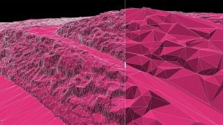
A video crew follows senseFly's team of engineers marking a historic milestone in proof of surveying techniques, using eBee minidrones to map the epic Matterhorn and construct a 3D model of "the most beautiful mountain".

The mission involved the coordination of several teams with multiple eBee drones taking over 2200 images in 11 flights, all within a few hours of a sunny alpine morning. The results are stunning: a high-definition 3D point-cloud made of 300 million points covering an area of over 2800 hectares with an average resolution of 20 cm.

 

Author: senseFly
Tags:
You may also like...
V-Ray 7, Update 5: AI Scene Building and AMD GPUs Meet Real-Time Ray Tracing

V-Ray 7, Update 5: AI Scene Building and AMD GPUs Meet Real-Time Ray Tracing

Chaos embeds AI assistants, MCP server integration with Claude and ChatGPT, 2D-to-3D asset generation, and AMD GPU support into V-Ray 7, Update 5. The update also bundles Vantage real-time ray tracing access for Collection license holders, targeting faster workflows without compromising offline render quality.
×

LEAVE A COMMENT

You need to be logged in to leave a comment. Don't have account? Register now.